Patos Island Marine State Park History
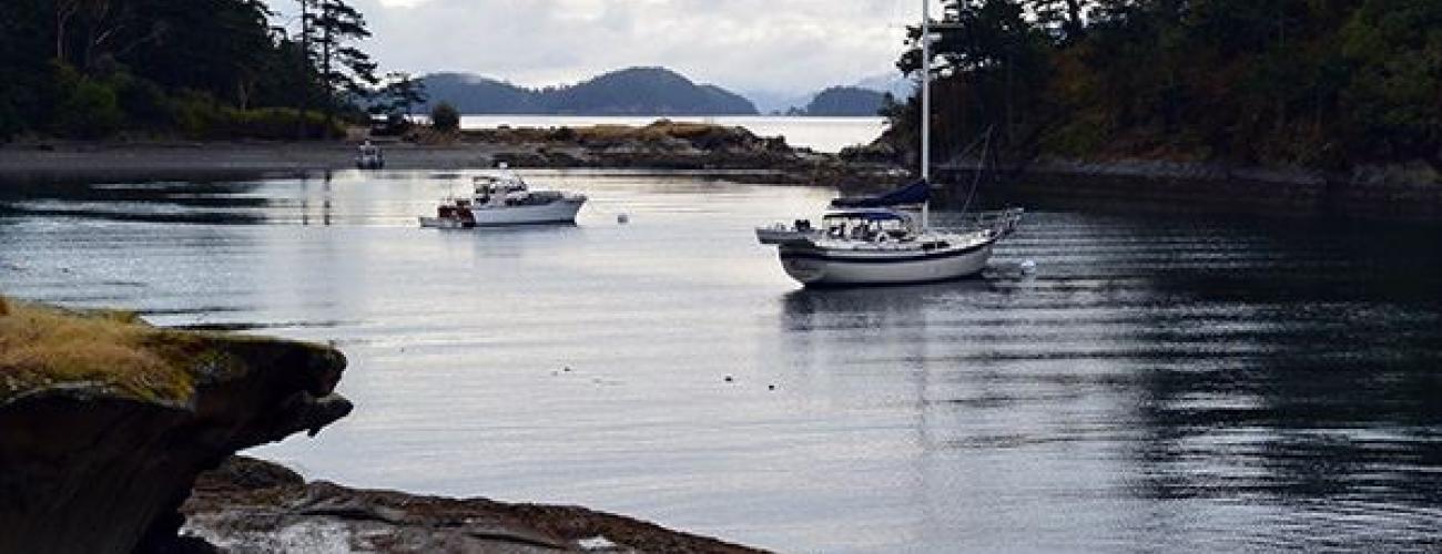
Patos Island Marine State Park provides a favorite campsite for paddlers and moorage for sailors, located on the northernmost edge of the San Juan Archipelago, noted for its historic lighthouse and wild, remote shores.
A Rocky Island
The San Juan Islands are distinct from most of Puget Sound in that they feature shorelines with exposures of hard bedrock, rather than the bluffs of clay, sand and gravel left by Ice Age glaciers that are predominant on most of Washington’s Salish Sea, the state’s inland saltwater passages.
Rock outcrops on Patos Island’s rugged shores reveal the bedrock of the island, made up of rock that formed by the hardening of sediments. Those individual grains were deposited about 50 million years ago by an ancient meandering river that carried gravel, sand and silt from what is today’s eastern Washington before the Cascade Mountains had begun to rise. Tropical forests grew along the river, and fossilized wood is included in the rocks. Geologists call these rocks the Chuckanut Formation. The formation contains shale, sandstone and conglomerate, each type of rock a product of deposition in different environments along the river.
The sandstone of the Chuckanut Formation at the shores of Patos Island has been sculpted into intricate “honeycombs” by the absorption of salty seawater into the porous sandstone during high tides, followed by evaporation and expansion of salt crystals when the rock dries and warms during low tides.
Between Patos Island and Little Patos Island lies protected Active Cove, eroded by wave action from the less-resistant shale of the Chuckanut Formation. Harder sandstone and conglomerate remain as ridgelines on the islands, reaching 103 feet above sea level.
Indigenous Land
The park lies within the traditional territory of Coast Salish Indigenous people whose present-day descendants include members of the Lummi Nation, Samish Indian Nation, Swinomish Indian Tribal Community, and First Nations in Canada.
For thousands of years the lands and waters of the San Juan Archipelago have provided habitat for a diverse community of life that forms the basis of their cultures. As winter days lengthen into spring, herring and herring roe collect in the eelgrass beds near shore. A little later, spring Chinook salmon pass through the island channels. Early summer brings sockeye salmon, harvested for millennia with reef nets. Sea urchins are gathered by expert divers in late summer, and clamming peaks in the fall.
European Competition
In the 1700’s many European nations attempted to discover and claim a “Northwest Passage” connecting the Atlantic and Pacific Oceans. The Spanish Crown claimed exclusive rights to colonize the west coast of North America based on the 1494 Treaty of Tordesillas. Eight Spanish expeditions between 1774 and 1790 charted parts of today’s Pacific Northwest coast and established a Spanish settlement at Nootka Sound on Vancouver Island. In 1791, Spanish Naval Officer Francisco de Eliza y Reventa was sent to reinforce the Spanish presence at Nootka Sound and direct further exploration of the Strait of Juan de Fuca as a possible Northwest Passage. In 1792, his compatriots Dionisio Alcala Galiano and Cayetano Valdez built upon Eliza’s work to compile an authoritative map of the Strait of Juan de Fuca, Strait of Georgia, and the San Juan Archipelago, recording today’s Patos Island as “Isla de Patos,” translated to “Island of Ducks.” They shared their chart with Captain George Vancouver when they met near today’s Vancouver, BC, later that year. Spain ultimately dropped its claim to the Pacific Northwest, leaving only the British and Americans with plans to colonize the territory. The name “Patos Island” was adopted by the United States Coast Survey in 1854.
The survey was undertaken under the direction of Lieutenant James Alden, who piloted the 172-foot US Coast Survey steamer Active to the region in 1852. Over the course of several seasons, Alden’s crew completed accurate charts of the coastline of the Salish Sea, the inland saltwater passages within Washington.
In recognition of Alden’s accomplishments, the northwest point of Patos Island was named Alden Point, and the protected bay between Patos and Little Patos Islands was charted as Active Cove.
The Pig War
The dual claims to the Pacific Northwest by the US and Britain were negotiated in 1846, setting the land boundary at 49° north latitude, but the status of the San Juan Archipelago remained disputed, as British and American authorities disagreed over the placement of the maritime border between Vancouver Island and the mainland.
On June 15, 1859, Lyman Cutlar, an American farmer claiming land on San Juan Island under terms of the Donation Land Claim Act, shot a pig owned by an employee of the British Hudson’s Bay Company. Cutlar’s offer of restitution was spurned and British authorities threatened to arrest Cutlar. American settlers asked for US military protection. Captain George Pickett (of later infamy for his role as a Confederate officer) and 66 soldiers of the 9th Infantry Regiment responded from Fort Bellingham, establishing a camp at the south end of the island. Additional US troops were transferred from Fort Townsend.
Alden, still in command of the Active, served as a dispatcher, carrying messages to and from US military forces, and even attempting diplomacy with his British peers, with no apparent success.
The British sent three ships under the command of Captain Geoffrey Hornby in response, building fortifications on the north end of the island with orders from James Douglas, the governor of the Vancouver Island colony, to remove the Americans from the island. Hornby refused the order, waiting for instructions from Rear Admiral Robert Baynes. Baynes countermanded the order, saying he would not escalate the conflict into war “over a squabble about a pig.”
US negotiators likewise desired to de-escalate the situation, as their focus shifted to the early stages of the US Civil War. Negotiations resulted in a joint occupancy agreement, with forces reduced to no more than 100 personnel, who enjoyed amicable social relations for the duration of the occupation.
In 1871, the Treaty of Washington between the US and Great Britain mandated the submission of the competing claims for adjudication by a commission appointed by German Kaiser Wilhelm I. On October 21, 1872, the commission decided in favor of the American claim. The British Royal Marines withdrew on November 25, 1872, and the American troops had all returned to Fort Townsend by July 1874.
Local tribes had ceded ownership of the area to the US federal government under duress in the Treaty of Point Elliot in 1855, in spite of the as-yet unsettled colonial administration of the San Juan Archipelago. After the jurisdiction was settled, the ceded lands became part of the federal public domain lands. The tribes reserved rights to harvest natural resources in their usual and accustomed places, including the lands and waters surrounding Patos Island.
Patos Island was withdrawn from entry for homesteading or other transfers from the public domain when it was established as a federal lighthouse reservation in 1875.
Patos Island Light Station
Building on the recommendations of Alden’s coast survey, a Fog Signal Building was built near Alden Point in 1893. The building was replaced with an improved version in 1898. In 1905, plans were drawn for a 38-foot light tower to be added to the fog signal, and it was completed by 1908, with a fourth-order Fresnel lens to amplify the light from an oil-burning wick.
Patos Island’s first lightkeeper, Harry Mahler, noted to a reporter in 1917 that “Whenever a lighthouse keeper is mentioned the adjective ‘lonely’ is always invoked. But they are all wrong. It’s not a lonely life from my viewpoint.”
In 1905, Edward Durgan was appointed lighthouse keeper at Patos Island, moving to the island with his wife and many of his 13 children. One of them, Helen Durgan Glidden, published a somewhat fanciful memoir of her childhood on the island, The Light on the Island, in 1951.
On June 24, 1974, the Patos Island Light was automated. Over time the buildings fell into disrepair.
Making a Park
On August 19, 1974, the Washington State Parks and Recreation Commission (WSPRC) agreed to enter into a five-year license agreement with the US Coast Guard (USCG) for the development and maintenance of primitive campsites by the shore of Active Cove.
The light station on Patos Island was listed on the National Register of Historic Places in October 1977. In 1987, the USCG relinquished most of Patos Island to the federal Bureau of Land Management (BLM) for ownership and management, and the remaining five acres including the light station were relinquished in 2002. BLM staff contracted for the dismantling of all of the buildings except the 1898 lighthouse building and the 1908 tower addition. With the assistance of a non-profit friends group established in 2007, the BLM renovated the remaining lighthouse building.
On March 8, 2007, the US Bureau of Land Management (BLM) and the WSPRC entered into an agreement to provide recreation facilities on Patos Island.
San Juan Islands National Monument
In 2011, a group of leaders from San Juan County began advocating for the establishment of a protected area made up of the remaining federal public domain lands located in the San Juan Archipelago, including Patos Island. In response, US Secretary of the Interior Ken Salazar directed the manager of the BLM Wenatchee Field Office, Karen Kelleher, to coordinate development of a proposal to designate the lands as a National Conservation Area. On November 10, 2011, Salazar forwarded a report to Congress outlining a proposal for the protected area.
Senator Maria Cantwell introduced legislation in the US Senate to accomplish the task, and a hearing was held on the legislation on March 22, 2012. However, opposition to the proposal was voiced by Representative Doc Hastings, who stated that “the country can’t afford any more public land,” and refused to advance the proposal in the US House of Representatives.
On March 25, 2013, President Barack Obama issued Presidential Proclamation 8947, designating the 1,021-acre San Juan Islands National Monument to protect the federal lands, including Patos and another BLM property leased by the WSPRC at Blind Island Marine State Park. Patos Island alone makes up about 20% of the land area of the monument. In the proclamation, President Obama noted that the monument would serve as a “refuge of scientific and historic treasures and a classroom for generations of Americans.”
Sharing the histories of Washington’s state parks is an ongoing project. Learn more here.

