Matia Island Marine State Park History
Matia Island Marine State Park provides off-the-beaten-path recreation experiences in a place with stories that extend well beyond its shores.
Sandstone Sculpted by the Sea
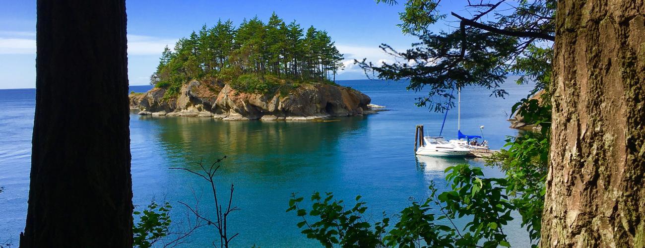
Rock outcrops on the island’s rugged shores reveal it’s bedrock, formed by the hardening of sediments. Individual grains of sand were deposited about 50 million years ago by an ancient meandering river that carried gravel, sand and silt from what is today’s eastern Washington, before the Cascade Mountains had begun to rise. Tropical forests grew along the river, and fossilized wood is included in the rocks. Geologists call these rocks the Chuckanut Formation. The formation contains shale, sandstone and conglomerate, each type of rock a product of deposition in different environments along the river.
The sandstone of the Chuckanut Formation at the shores of Matia Island has been sculpted into intricate “honeycombs” by the absorption of salty seawater into the porous sandstone during high tides, followed by evaporation and expansion of salt crystals when the rock dries and warms during low tides.
The island’s shoreline includes two significant coves, Rolfe Cove on the northwest side of the island and an unnamed cove on the southeast side. The two coves are linked by two small valleys which have been eroded from the less resistant shale. Harder sandstone and conglomerate remain as three parallel ridges across the island reaching 162 feet above sea level.
Indigenous Lands
Matia Island lies within the traditional territories of Coast Salish Indigenous people whose present-day descendants include members of the Samish Indian Nation, Swinomish Indian Tribal Community, Lummi Nation, Suquamish Tribe, and First Nations in present-day Canada. For thousands of years, the lands and waters of the San Juan Archipelago have provided habitat for a diverse community of life that forms the basis of their cultures.
Camas roots were traditionally harvested on Matia Island, with visits to the same locations each year—rocky ledges with shallow soil that made digging the bulbs easier. Gathering was done with a fire-hardened stick of ironwood (also commonly called ocean spray, Holodiscus discolor), sharpened at both ends. Ethnologist Bernhard J. Stern wrote in 1934 that women of the Lummi Nation “cut the earth in small sections, lift the soil with the sticks and collect the bulbs in their baskets. They crush the soil directly afterwards and plant the seeds broken from the stems.” Bulbs were steamed in large holes dug in the ground and filled with heated rocks which were removed after a short period. Raw camas was placed on a bed of sword ferns in the heated hole, then left to steam for two to three days.
Lummi gatherers also traditionally collected the eggs of puffins, murres, auklets, and pigeon guillemots that nested on Matia Island.
What’s in a Name
In the summer of 1791, Spanish naval officer Francisco de Eliza y Reventa commanded the Spanish outpost at Nootka Sound on today’s Vancouver Island. Anticipating having to move the outpost due to high-level diplomatic negotiations between Spain and Britain, Eliza headed an exploration voyage into the poorly charted waters of today’s Salish Sea to better understand Spain’s options.
Eliza and his fellow officer, Jose Maria Narvaez, charted the islands and passages of the San Juan Archipelago, recording today’s Matia Island as “Isla de la Mata,” roughly translated to “Island of the Woods,” recognizing that the island is more densely forested than other nearby islands. The name was perpetuated by Spanish navigators Dionisio Alcala Galiano and Cayetano Valdes on their charts of the islands in 1792, which they shared with British explorer Captain George Vancouver when they met during that year. Spain ultimately dropped its claim to the Pacific Northwest, leaving only British and American with plans to colonize the territory. The name “Matia” was conferred by the United States Coast Survey in 1854, probably an inadvertent misspelling of Eliza’s descriptive name.
The Pig War
The dual claims to the Pacific Northwest by the US and Britain were negotiated in 1846, setting the land boundary at 49° north latitude, but the status of the San Juan Archipelago remained disputed, as British and American authorities disagreed over the placement of the maritime border between Vancouver Island and the mainland.
On June 15, 1859, Lyman Cutlar, an American farmer claiming land on San Juan Island under terms of the Donation Land Claim Act, shot a pig owned by an employee of the British Hudson’s Bay Company. Cutlar’s offer of restitution was spurned and British authorities threatened to arrest Cutlar. American settlers asked for US military protection. Captain George Pickett (of later infamy for his role as a Confederate officer) and 66 soldiers of the 9th Infantry Regiment responded from Fort Bellingham, establishing a camp at the south end of the island. Additional US troops were transferred from Fort Townsend (which is also now a Washington state park).
The British sent three ships under the command of Captain Geoffrey Hornby in response, building fortifications on the north end of the island with orders from James Douglas, the governor of the Vancouver Island colony, to remove the Americans from the island. Hornby refused the order, waiting for instructions from Rear Admiral Robert Baynes. Baynes countermanded the order, saying he would not escalate the conflict into war “over a squabble about a pig.”
US negotiators likewise desired to de-escalate the situation, as their focus shifted to the early stages of the US Civil War. Negotiations resulted in a joint occupancy agreement, with forces reduced to no more than 100 personnel, who enjoyed amicable social relations for the duration of the occupation.
In 1871, the Treaty of Washington between the US and Great Britain mandated the submission of the competing claims for adjudication by a commission appointed by German Kaiser Wilhelm I. On October 21, 1872, the commission decided in favor of the American claim. The British Royal Marines withdrew on November 25, 1872, and the American troops had all returned to Fort Townsend by July 1874.
The Hermit of Matia Island
Local tribes had ceded ownership of the area to the US federal government under duress in the Treaty of Point Elliot in 1855, in spite of the fact that colonial administration of the San Juan Archipelago was not yet settled. In the treaty, Indigenous residents kept rights to harvest natural resources in their usual and accustomed places throughout the islands, especially at reef net sites owned by tribal members. All of Matia Island was reserved for lighthouse purposes by a presidential order in 1875, but no lighthouse was ever built.
In an unfounded anticipation that the lighthouse reservation would be revoked, Civil War veteran Elvin H. Smith settled on the island in 1892, planning to eventually claim the land for real estate speculation. The land was never opened for land claims or sale, but Smith decided to stay in the cabin he built on the island’s southeast cove. He fished for cod and salmon, raised chickens, rabbits and sheep and grew apples, pears, prunes and cherries. In 1905, he wrote to a cousin that:
“The scenery is grand every clear day. On stormy or windy days the sea is equally grand and terrible. It is a constant lovely dream…. I claim to be the healthyest (sic) and most contented man in San Juan Co.”
He also said that the island was “a wonderful place for study,” and his home was filled with books, magazines and papers. Smith studied and wrote about Therapeutic Suggestion, Auto Suggestion and Telepathy, especially as tools for recovery from anger and alcoholism. He also received fan mail and maintained correspondence with many people.
On February 23, 1921, Smith and a friend disappeared without a trace while boating between Orcas Island and Matia Island.
Making a Park
On March 30, 1937, President Franklin D. Roosevelt declared Matia Island a Migratory Bird Refuge with Executive Order 7595, “in order to effectuate further the purposes of the Migratory Bird Conservation Act.” The primary objective of the refuge was to protect the nesting sites of puffins, murres, auklets, and pigeon guillemots, birds whose numbers were declining due to loss of habitat. The order also revoked the earlier lighthouse reservation.
Proclamation 2416 in 1940 changed the name of the protected area to Matia Island National Wildlife Refuge. In 1959, the agency entered into an agreement with the Washington State Parks and Recreation Commission (WSPRC) to develop and operate recreation facilities on the island. The WSPRC developed a dock and moorage at Rolfe Cove, as well as camp and picnic sites on the slopes above.
A Wilderness Island
On September 3, 1964, President Lyndon B. Johnson signed the federal Wilderness Act, to designate areas of federal lands as part of a National Wilderness Preservation System (NWPS), to perpetuate their wilderness character. Wilderness was defined as an area where the “earth and its community of life are untrammeled by man, where man himself is a visitor who does not remain.”
The law directed all federal land management agencies, including the US Fish and Wildlife Service, to review their roadless lands, including every roadless island, within ten years and make recommendations to Congress as to their suitability for inclusion in the NWPS.
On October 19, 1976, President Gerald Ford approved Public Law 94-557, establishing the San Juan Islands Wilderness, including all of Matia Island except the five-acre parcel leased by the WSPRC as Matia Island State Park.
The wilderness designation prompted the US Fish and Wildlife Service to enact protective rules for the island, which include the prohibition of pets that could stress or harm birds and other wildlife. Human use of the island beyond the five-acre state park site is limited to walking along the one-mile Wilderness Trail, which loops through the island’s two valleys, connecting Matia Island State Marine Park with the site of Elvin H. Smith’s former home.
Sharing the histories of Washington’s state parks is an ongoing project. Learn more here.

