Doug's Beach State Park History
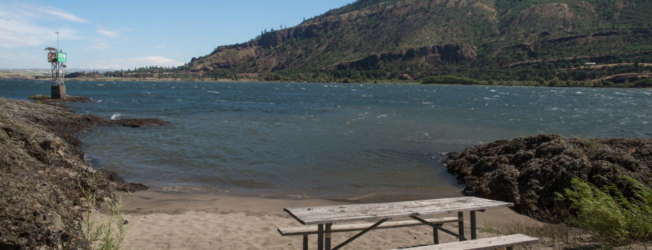
Doug’s Beach State Park is a legendary launch site for enjoying wind sports on the swells of the Columbia River reservoirs, situated in a place with spectacular scenery and a long cultural history.
The Winds of Rowena Gap
The bedrock landscape of Doug’s Beach State Park was formed by the eruption of the Columbia Plateau flood basalts. The basalt lava erupted from fissures in today’s southeastern Washington, produced by an upwelling of molten magma from deep in the Earth’s interior. Numerous lava flows spread out over much of the eastern parts of today’s Washington and Oregon. Some flowed down along the course of the ancient Columbia River. The flows hardened into the basalt columns that form the cliffs soaring above the river in today’s park. Later, as the Cascade Mountains bulged upward, the river carved its course down through the lava flows, creating the Columbia River Gorge.
The rocky cliffs and benches above the day-use areas in today’s park were later eroded by a series of glacial lake outburst floods that blasted across the Columbia Basin near the end of the last ice age. The floods were released when huge ice-dammed lakes far upstream broke through the ice, scouring away accumulated soils and fractured rocks, leaving stark rock walls. Doug’s Beach State Park is situated in a constriction of the Columbia River Gorge called Rowena Gap.
This area is famous for sustained high winds, especially in the spring and summer months. The wind is caused by differences in air pressure between the hot, arid east end of the Columbia Gorge and the wetter, cooler west side. The cooler, denser air on the west side moves under the warmer, dryer air of the east side, creating reliable winds throughout the gorge. The narrowness of Rowena Gap amplifies the wind intensity.
Indigenous Lands
Doug’s Beach State Park lies within the traditional territories of Indigenous people whose present-day descendants include members of the Confederated Tribes and Bands of the Yakama Nation, the Confederated Tribes of the Umatilla Reservation, and the Confederated Tribes of Warm Springs Reservation of Oregon.
Traditionally, some of the Indigenous people of the region left winter residences along the Columbia River and its tributaries in the spring to travel to surrounding areas to collect, hunt, fish and trade on seasonal rounds. The rivers have long served as the primary transportation corridors in the region as well as the source of salmon, a mainstay of Indigenous food and culture. Now-flooded Celilo Falls and the Short and Long Narrows of the Columbia River, a short distance upstream from today’s Doug’s Beach State Park, were at the heart of the economic and cultural hub of Indigenous life in the region.
The Friendly Village
On October 29, 1805, the Corps of Discovery led by Meriwether Lewis and William Clark passed the site of today’s park on their outward jouney down the Columbia River to the Pacific Ocean. Spotting an Indigenous village there, they landed on shore. Clark noted in his journal that “those people are friendly gave us to eate fish Beries, nuts bread of roots & Drid beries and we Call this the friendly Village. We purchased 12 dogs of them & 4 Sacks of Pounded fish, and some few Dried berries and proceeded on.”
A month later, as the Corps debated where to locate their winter camp, the “Friendly Village” in the Columbia River Gorge was one of the sites discussed, though they ultimately decided to stay near the Pacific Ocean coast.
Representatives of numerous Indigenous people with traditional territories in the region negotiated and signed treaties with Territorial Governor Isaac I. Stevens at Walla Walla on June 9, 1855. The treaties would not be ratified by the US Senate until 1859, and in the interim, the benefits promised by the treaties were not available to the tribes that had signed. Most Indigenous people chose to initially continue their seasonal rounds, rather than be confined to reservations as stipulated in the treaties.
Trespass by American settlers led to armed conflict between Indigenous warriors and the US Army, culminating in the Battle of Spokane Plains on September 5, 1858. Ultimately, Indigenous lands were relinquished to the US government and the people largely moved to the designated reservations, traveling to traditional fishing sites along the Columbia River seasonally, as a guaranteed treaty right.
Government Survey and Statehood Land Grant
Government surveys of the land in today’s park were completed in 1861, but none of the property was transferred to private owners through federal land disposal laws such as the Homestead Act.
When Washington Territory was created by an act of Congress in 1853, survey sections 16 and 36 in each township were reserved to be granted to the eventual State of Washington to be held in trust to support public institutions. In places where the reserved sections were already occupied by homesteaders, part of a forest reserve, military reservation or Native American reservation, the county commissioners in the affected county were authorized to locate other lands of equal extent “in lieu of” the unavailable lands. In Klickitat County, lieu lands were selected to replace sections that were part of the Yakama Indian Reservation. Subsequently, the land in today’s Doug’s Beach State Park was selected to fulfill the promised grant. The land passed into state ownership as a trust “for all the people” to support public schools on February 11, 1897.
At Play in the Wind
The sport of windsurfing experienced significant growth and recognition in the late 1970s as inventors and entrepreneurs developed surfboards with maneuverable sails to take advantage of the wind-generated waves of the Columbia River reservoirs.
In 1984, Dr. Doug Campbell, an epidemiologist at the Oregon Health Division in Portland, co-founded a small business to support the sport that he loved. He initially commuted from his city job on weekends to work at their shop, Hood River Windsurfing, but eventually it became his full-time job. Able to devote time to seeking out the best ‘surfing places in the Gorge, Campbell expanded his business to provide travel arrangements for international visitors who wished to experience the “windsurfing capital of the world” in the Columbia River Gorge.
Windsurfers often found difficulty accessing the shoreline to launch their craft, due to private property and the danger of trespassing on railroad rights-of-way. The expanse of state-owned trust land at “Doug’s Beach” eliminated the first problem, but Doug and his fellow athletes still had to take a risk crossing the railway lines there.
Making a Park
On September 1, 1988, the Washington State Parks and Recreation Commission (WSPRC) obtained a Right of Entry Permit from the Department of Natural Resources (DNR) to construct recreational facilities and parking areas at Doug’s Beach funded by a $50,000 appropriation from the legislature.
In 1989, the Washington State Legislature authorized the Trust Land Transfer Program to fund the transfer of state trust lands with special ecological or social values that have low income potential out of state trust ownership to a public agency that can manage the property for those values. Money from the transfer provides revenue for the trust beneficiaries and is used to buy productive replacement properties that will generate future trust income.
On February 26, 1993, the WSPRC acquired the 400 acres of state trust land that make up Doug’s Beach State Park under terms of the Trust Land Transfer Program, with a legislative appropriation of $341,000 to the trust.
The WSPRC approved the construction of expanded parking, sanitary facilities and a controlled railroad crossing at the park, ensuring safe access for recreation even as Columbia River Gorge wind sports evolved into new endeavors such as kite boarding and wing foiling.
Sharing the histories of Washington’s state parks is an ongoing project. Learn more here.

