Crawford State Park Heritage Site History
An Underground Wonderland
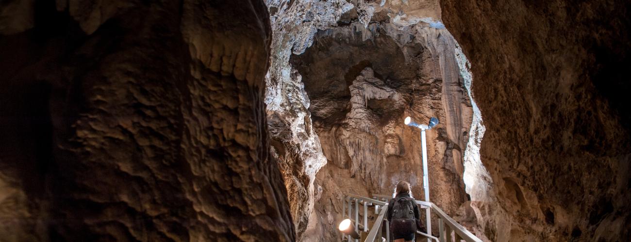
Crawford State Park Heritage Site preserves Gardner Cave, one of the largest limestone caverns in Washington. The cave is adorned with fantastic and delicate natural decorations that have formed over thousands of years.
The park is located in the northeast corner of today’s Washington State, an area that would have been the western edge of the North American continent 500 million years ago. Offshore, shells of marine organisms and coral reefs accumulated on the continental shelf, decaying into a limey ooze and eventually compressing to form an assemblage of rocks that geologists call the Metaline Formation, which includes massive limestones interbedded with shale and other oceanic sedimentary rocks. The formation is estimated to be about 1,500 feet thick in the vicinity of Gardner Cave.
Eventually, tectonic forces began the slow subduction of oceanic crustal plates underneath the west coast of North America, and the addition of terranes, or blocks of crust moved from other areas by tectonic action, which expanded the continental edge and thickened the crust in the area of today’s Crawford State Park Heritage Site. These processes lifted and tilted the Metaline Formation into its present location. Gardner Cave’s entrance is located nearly 2,800 feet above sea level, and the limestone beds dip more than 21° toward the southwest.
The formation of Gardner Cave is a much more recent phenomenon and consists of two distinct phases: the carving of the passages and deposition of the decorations, or speleothems.
Passages & Decorations
The beginnings of Gardner Cave were stress fractures in the Metaline Formation caused by the tectonic forces it had endured. Starting up to 15 million years ago, rainwater seeped into the fractures. The rainwater, being slightly acidic from its absorption of carbon dioxide from the atmosphere and decaying organic material in the soil, began to dissolve the limestone.
Hydrologists refer to this phase as phreatic, in which the slowly enlarging passages are entirely filled with water, slowly dissolving the surrounding limestone. As the tube enlarged, water flowed faster, creating the scallops and ripples seen on the walls of Gardner Cave.
As the cave got even larger, water no longer filled the entire cavity. Continuing to the present day, acidic rainwater seeping into the cave carries dissolved limestone in solution, but only until it reaches the air within the cave passage. Hydrologists call this vadose water. When a drop of rainwater enters the cavern, the carbon dioxide carried in the solution is released into the air, and the dissolved limestone is deposited as the mineral calcite. The coloration of calcite deposits can vary somewhat due to inclusion of other minerals, and some of the calcite in the cave is classified as “moonmilk,” a soft and spongy deposit with a cloudy white coloration that may be the result of microbial or fungal growth within the deposit. Calcite deposits in Gardner Cave (speleothems) come in many forms and have been decorating the cave for about 90,000 years.
- Flowstone is formed as wide, thin sheets as calcite is deposited by vadose water flowing along the walls and floor of the cave.
- Stalactites begin when a single drop of water clings to the ceiling. Calcite is precipitated around the outside of the drop, leaving a hollow tube. Another drop extends the tube forming a soda straw, getting longer and longer. Eventually the tube is plugged and water flows down the outside of the formation, extending the stalactite.
- Stalagmites are formed when a drop of water falls off the tip of a stalactite and still has enough calcite in solution to deposit it where it lands, eventually building upwards toward the source of the water drop on the cave ceiling. (Stalagmites “might” reach the ceiling; Stalactites hang “tight” to the ceiling)
- Gardner Cave is famous for its Column, formed when a stalactite and stalagmite joined together.
- Cave Popcorn forms on cave walls when there is water being pushed from behind the wall under pressure by capillary action.
- Helictites are formed in a similar way to cave popcorn but continue to form tubes seemingly without regard to the influence of gravity, growing up, sideways, and into curls!
- Gours, or rimstone dams, form as a drop of water with calcite in solution falls into a pool of water. Each drop creates a ripple, and the ripple carries the calcite to the rim of the pool where it is deposited.
Indigenous Lands
Crawford State Park Heritage Site lies within the traditional territory of Interior Salish Indigenous people whose present-day descendants include members of the Kalispell Tribe of Indians and the Confederated Tribes of the Colville Reservation.
Members of the tribes occupying this area were not represented at the Walla Walla Treaty Council held by Territorial Governor Isaac Stevens on June 9, 1855. Subsequently, an Executive Order of President Ulysses S. Grant on April 9, 1872 created a reservation, covering the area bounded by the Columbia, Spokane and Pend Oreille Rivers. The order stipulated that the reservation was designated for the Indigenous bands specified in the order, and for “such other Indians as the Department of the Interior may see fit to locate thereon.” On July 2, 1872, the reservation was relocated to the area between the Columbia and Okanogan Rivers and designated as the Colville Indian Reservation. The Kalispel Reservation was established by an executive order of President Woodrow Wilson on March 23, 1914.
On March 1, 1907, President Theodore Roosevelt established the Colville National Forest on unclaimed public domain lands of the former Columbia Reservation. Today’s Crawford State Park is bordered by the Colville National Forest on two sides.
An official government survey of the township including the area of today’s Crawford State Park Heritage Site was completed in 1913. However, due to the inexact location of the US/Canada border, fractional parcels of land abutting the border were not officially surveyed and recorded until July 27, 1920. The land in today’s park was then sold from the public domain to William H. Crawford as a Cash Entry patent on August 6, 1920.
Ed and Billy
There is no way to know when the first person entered Gardner Cave, but it enters the historical record around the turn of the 20th century. It is reputed that Edward (Ed) E. Gardner discovered the entrance to the cave that now bears his name while hunting in the hilly forested area behind his cabin. Some stories say that he identified the collapse pit that is the cave’s entrance when he saw a steam-like condensation vapor rising from the ground.
Edward Gardner came to the Pend Oreille Valley before 1900 and sporadically worked in local mines. He built a cabin on the west shore of the river a short distance south of the US-Canada border but could not file a homestead claim at the time, as the government survey had not been completed.
In the 1980s, Park Ranger Merriann Kane-John conducted interviews with local residents who had known Gardner. When asked what Gardner did for a living, most agreed with Gardner’s neighbor Herman Kempe, who stated: “He was down there muckin’ around – he had a little place he had about five acres cleared down there and he fiddled around and bootlegged. He had a brother in Seattle who was a banker and sent money at times.” Though many residents related stories of buying distilled liquor from Gardner, especially during the Prohibition Era, it is unclear whether he made the products himself, transported them across the border from Canada, or both.
Ed, along with his neighbors the Kempes and Bill Nelson, who operated a grocery-delivery pack string for local homesteaders, occasionally guided curious visitors into Gardner Cave.
Gardner received Homestead Patents from the federal government in 1920 and 1925, having “proved up” his claims to 167 acres by clearing some areas and building and residing in a home there. Sickened with ulcers, he took his own life in early January 1937, when he was 69 years old. His obituary in the local newspaper stated: “He was a recluse with many friends among the older settlers of the region. He discovered Gardner Cave in what is now Crawford State Park.” His heir eventually sold the land to Seattle City Light in the early 1960s as construction of Boundary Dam began.
William (Billy) H. Crawford was, like Gardner, a lifelong bachelor, a Metaline store owner, postmaster, and a booster for growth and tourism in the area, especially after a railroad was extended to the town. Photographs of Gardner Cave were included in railroad advertisements, and Crawford saw the cave as a unique and beautiful feature that could be used to lure tourists to the community. As soon as practicable after government surveys were completed, he purchased 157 acres of public domain land including Gardner Cave.
Making a Park
William Crawford then donated 40 acres of his property encompassing the entrance of Gardner Cave to the State Parks Committee on October 20, 1921. The State Parks Committee accepted the donation on November 10, 1921, establishing one of Washington’s first state parks, named in honor of the donor. Initially, access was only available by a trail from the road at Will Halstead’s sawmill on Russian Creek. No developments were made to the cave until the 1950s, when wooden ladders were added in some locations and wires were strung between ceramic insulators to provide power to hanging light bulbs.
The cave was open and accessible to anyone during this time, and the cave was damaged by graffiti, breakage (over 1,000 broken stalactites were recorded in a 1981 survey), smoking, and oil deposited by handling cave features. Reports of vandalism at the cave spurred the Washington State Parks and Recreation Commission (WSPRC) to completely close the park for a time, beginning on February 20, 1948.
After consultation with staff at a number of caves managed by the National Park Service, the WSPRC authorized an upgrade to provide a safer experience for park visitors and better protect the cave’s unique qualities. Steel stairs and walkways were installed in the cave in the summer of 1977, and access was restricted to guided tours led by WSPRC staff.
With the new access, 494 feet of the cave’s 2,072 feet of known passageways can be visited, highlighting some of the cave’s best features.
Sharing the histories of Washington’s state parks is an ongoing project. Learn more here.

