Miller Peninsula State Park History
Miller Peninsula State Park Property holds the potential to become one of Washington’s most beloved state parks. Perched on forested bluffs overlooking the marine passage into Washington’s inland waterways and sandwiched between the protected harbors of Discovery Bay and Sequim Bay, this quiet landscape has nonetheless been touched by many lives. For the S’Klallam people, this land is part of a homeland that spans the shores and uplands of the Strait of Juan de Fuca. Discovery Bay was the first point of anchorage at the beginning of Captain George Vancouver’s detailed survey of the coast of what would become the state of Washington. Land speculators purchased timberlands here, hoping to get a rich return on their investments. A military reservation was established with an aim toward strategically protecting growing cities on Puget Sound. No fort was constructed on the property. More recently, land managers and state government leaders recognized the public values of this landscape. Translating that acknowledgement into balanced public policy for the land is a continuing challenge.
Glacial Debris
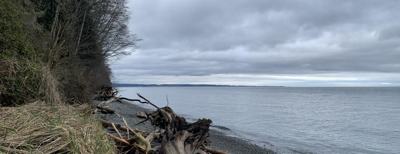
Around 17,000 years ago, a lobe of the continental ice sheet filled most of today’s Salish Sea basin during its last major advance into the region. The ice reached a thickness of nearly 4,000 feet in the area of today’s park. Around 16,000 years ago warming temperatures caused the ice to melt. The lobe of ice reaching along the course of today’s Strait of Juan de Fuca melted very rapidly, influenced by rising saltwater undermining and calving vast chunks of glacial ice. The melted ice left behind the sand, gravel, and clay that had been locked within the ice for thousands of years. Miller Peninsula’s bluffs and beaches all owe their forms to this pile of debris from long ago.
The Great Draining of Lake Bretz
J Harlen Bretz is famous for his geologic sleuthing of the story of the Dry Falls of the Grand Coulee in eastern Washington. Less well known are his investigations into the glaciation of western Washington. In the early 1910s, he published investigations, revealing that a very large proglacial lake had formed as water melted from the southern end of the Puget Lobe of the great ice sheet. This lake found an outlet to the Pacific Ocean by way of the Chehalis River Valley to the south. Bretz named the vanished body of water Lake Russell, in honor of Israel C. Russell, a government geologist who had recognized the evidence of glaciations in western Washington over a decade earlier.
In the 1980s, geologist Robert Thorson extended Bretz’s work, specifically examining the progressive changes to the landscape as the ice sheet melted. He found that as the Puget lobe retreated farther north, a new spillway opened to the north, allowing a catastrophic rush of water to drain through a channel which emptied through today’s Discovery Bay, followed by the establishment of a new proglacial lake which he named Lake Bretz, in honor of J Harlen Bretz’s revolutionary work to understand the power of Ice Age flood processes.
The dramatic floods of glacial meltwaters ended in the area of today’s Miller Peninsula, but the interactions of the earth’s surface rebounding upwards due to the release from the weight of the ice versus rising sea levels from the pouring of melted glacial ice into the oceans continued. Initially, sea level rise outpaced rebound—local sea level was nearly 600 feet higher on the landscape about 14,000 years ago. Within another 2,000 years, however, the situation had reversed, with relative sea level dropping to nearly 200 feet lower, as the land continued to rise. By about 6,000 years ago, sea level had stabilized near its present position. Today, the pile of glacial debris that is Miller Peninsula is flanked by two deep bays, Discovery Bay and Sequim Bay.
Indigenous Lands
Miller Peninsula State Park Property lies within the traditional territories of Coast Salish Indigenous people whose present-day descendants include members of the Jamestown S’Klallam Tribe, Port Gamble S’Klallam Tribe, and Lower Elwha Klallam Tribe. For thousands of years this area has provided habitat for a diverse community of life that forms the basis of their cultures.
Local tribes ceded ownership of the area to the US federal government under duress in the Treaty of Point No Point in 1855, keeping rights to harvest natural resources in their usual and accustomed places including the waters of Discovery Bay and Sequim Bay.
Most S’Klallam tribal members refused to leave their homeland and move to the Skokomish Reservation as provided for in the treaty, but the arrival of American settlers in the area pressured the S’Klallam to move away from traditional homes by Sequim Bay and Discovery Bay. In 1874, under the leadership of Chief James Balch, tribal members purchased 210 acres on Dungeness Bay that became the village of Jamestown. Indigenous residents of Jamestown lost federal tribal recognition under the terms of the treaty in 1953 but regained it in 1981 as the Jamestown S’Klallam Tribe with reservation land at the head of Sequim Bay. Related S’Klallam communities are organized as the Lower Elwha Klallam Tribe (to the west) and the Port Gamble S’Klallam Tribe (to the east). The northeastern point of Miller Peninsula was known as Clallam Point until 1941, when it was renamed Diamond Point.
The Vancouver Expedition—Discovery Bay
Competition between Spain and England for maritime and territorial control of the North Pacific coast of North America came to a head in the summer of 1789 when the commander of the Spanish outpost at Nootka Sound on today’s Vancouver Island seized British commercial ships engaging in fur trading with the Indigenous people of the area. War was nearly declared between Spain and Britain, until Spain backed down, realizing it could not count on an alliance with France, then preoccupied with the French Revolution. Spain and Britain negotiated joint claims of the area with the Nootka Convention in 1790.
In 1792, Captain George Vancouver was directed by the British Government to sail to Nootka Sound to meet Spanish commander Juan Francisco de la Bodega y Quadra, implement the terms of the Nootka Convention and complete a detailed survey of the Northwest Coast.
Though previous Spanish expeditions had made maps and charts of parts of today’s Salish Sea, Vancouver and his officers completed a much more rigorous survey. The expedition’s large ships, the Discovery and Chatham, carried eight smaller boats aboard to be used for detailed surveying close to the shoreline.
On May 2, 1792, Vancouver directed his ships to anchor about five miles within a deepwater bay which he christened “Discovery Bay” after the name of his ship. Unaware of the effects of Indigenous stewardship practices, he noted in his journal that:
“the country before us exhibited everything that bounteous nature could be expected to draw into one point of view. As we had no reason to imagine that this country had ever been indebted for any of its decorations to the hand of man, I could not possibly believe that any uncultivated country had ever been discovered exhibiting so rich a picture.”
While some officers calibrated their surveying equipment and other crew members repaired sails and performed maintenance on the ships, naturalist Archibald Menzies headed into the woods of Miller Peninsula to scout the native vegetation. Immediately he was enchanted by the sight of a “vast abundance of that rare plant the [Calypso orchid] which was now in full bloom…” and the very large trees that made up the deep forest.
Selling Off the Public Domain
The Oregon Treaty between the United States and Great Britain in 1846 established the border between the two countries’ colonial administration at the 49th parallel, putting the site of today’s Miller Peninsula State Park Property under American jurisdiction.
US Government surveys were completed in 1859, and parts of the Miller Peninsula were established as military reservations by an executive order of President Andrew Johnson on September 22, 1866. The same order established military reservations at Deception Pass, Fort Columbia, Fort Flagler, and Fort Worden, all of which would eventually become state parks.
The majority of the land that makes up today’s park was sold to private land speculators and investors under the Land Act of 1820, which offered public domain lands for sale at the rate of $1.25 per acre.
Some individuals purchased thousands of acres of timberlands in Washington Territory under these terms, hoping to eventually reap large profits from their investment as logging proceeded into every corner of the territory. Land on Miller Peninsula was highly sought for its wealth of forest growth and proximity to deep-water bays for easy shipping to mills.
Two of these land speculators, Charles H. Larrabee and William Craswell, were noted for purchases of thousands of acres throughout Washington Territory that would establish them as significant players in Washington’s timber industry.
Charles H. Larrabee was a relative of Charles X. Larrabee, another land speculator noted for his family’s donation of land that became Larrabee State Park, Washington’s first state park. Charles H. Larrabee was a congressman from Wisconsin and had served on the Wisconsin Supreme Court. During the Civil War, he was appointed by Wisconsin Governor Edward Salomon to organize and lead the 24th Wisconsin Volunteer Infantry Regiment. Injured in combat, he resigned from active duty in 1863 and moved west. Moving to Seattle in 1873, he contributed to the founding of the University of Washington. At the same time, he was locating and purchasing public domain lands throughout the territory. One purchase was a large block of land on Miller Peninsula that includes the park trailhead along Diamond Point Rd.
William Craswell followed his younger brother Robert to the Washington Territory from their home in Prince Edward Island, Canada. Craswell purchased three parcels in 1872 that are now located within today’s park property. One includes all of the park’s waterfront on Discovery Bay, and a portion of the Discovery Bay Trail. The second one includes waterfront on the Strait of Juan de Fuca and a portion of the Bluff Trail. The third parcel is located inland.
Interestingly, that parcel adjoins another one that was purchased by Edward S. Salomon, the eighth Territorial Governor of Washington (and a cousin of the Wisconsin governor who had appointed Charles H. Larrabee to his commission in the Civil War). A hero of the Battle of Gettysburg, Salomon was appointed by Ulysses S. Grant and served as governor from 1870-1872, notably the only Jewish person to hold Washington’s highest office. Salomon was caught up in scandals associated with the Grant administration and resigned on April 26, 1872. He purchased the Miller Peninsula land on May 1, 1872, five days after his resignation.
State Land
When Washington Territory was created by an act of Congress in 1853, survey sections 16 and 36 in each township were reserved to be granted to the eventual State of Washington to be held in trust to support public institutions. Today’s Miller Peninsula State Park Property includes a part of a section 16 land grant on its northeastern corner, containing part of the Alder Hollow Trail. The remainder of survey section 16 was included in the military reservation established in 1866.
In places where the reserved sections were already occupied by military reservations, the county commissioners in the affected county were authorized to locate other lands of equal extent “in lieu of” the unavailable lands.
Subsequently, the county commissioners selected adjoining tracts of public domain lands on Miller Peninsula to make up the promised grant. The selected tracts include today’s Beach Trail, the eastern part of the Bluff Trail, and the remainder of the Alder Hollow Trail.
Quarantine Station
The 1866 military reservation at Diamond Point was deemed unnecessary for national defense purposes in 1870, and some of the land was subsequently patented under terms of the 1862 Homestead Act by Matthew Fleming. In 1878, the US Congress passed the National Quarantine Act, which prohibited vessels from carrying infectious diseases into any US port.
Congress authorized $55,000 to build the Clallam Point Quarantine Station in 1893, and the Fleming homestead was taken by the government to build the station. All vessels arriving from foreign ports were required to be inspected. When deemed necessary, they were fumigated with burning pots of sulphur to kill fleas, rats, and lice. Passengers were inspected for symptoms of influenza, cholera, malaria, smallpox, yellow fever, diphtheria, and leprosy. Ships showing signs of disease were required to remain at quarantine until cleared.
The facility operated until 1936. Fire destroyed the site’s hospital building in 1948. By 1963, the site had been completely redeveloped by the Diamond Point Land Company, for residential use.
Towards Creating a State Park
In the 1970s, state park planners discussed ways of acquiring lands to meet the needs of Washington’s expanding population and provide additional opportunities for outdoor recreation. One proposed solution inventoried state trust lands that could fulfill recreational purposes. Miller Peninsula was one of the areas noted as being well-suited for park purposes.
The Miller Peninsula state land grant lands, managed by the Department of Natural Resources (DNR), had been expanded by transfers of tax delinquent lands held by Clallam County to DNR for forest management. The transferred lands included all of the properties originally purchased from the federal public domain by Charles H. Larrabee and William Craswell.
In 1985, a proposal backed by the Japanese Mitsubishi Group emerged. The proponents of the plan foresaw the development of 1,000 acres, including some of the Miller Peninsula state trust lands, with golf courses, hotels, shops, and residences for vacation rentals or employee housing.
Many local residents and others throughout the state opposed the plan, preferring the state lands to remain largely undeveloped beyond hiking and riding trails. Opponents organized and initiated protests and lawsuits to stop the proposed development. The project was ultimately dropped.
Trust Land Transfer
In 1989, the Washington State Legislature authorized the Trust Land Transfer Program. Under this law, the legislature funds the transfer of state trust lands with special ecological or social values that have low income potential out of state trust ownership to a public agency that can manage the property for those values. Money from the transfer provides revenue for the trust beneficiaries and is used to buy productive replacement properties that will generate future trust income.
Legislative action authorized the transfer of the trust lands on Miller Peninsula to the Washington State Parks and Recreation Commission (WSPRC) in three parcels totaling over 2,800 acres, and the transactions were completed on November 2, 1994.
An Age-Old Question: What Should a State Park Be?
Once acquired by WSPRC, the question still remained—how should the land be managed? Constrained by lack of funding for major park development, the WSPRC sought input from stakeholders to build a consensus for how the park lands should be developed. That process is ongoing.
Sharing the histories of Washington’s state parks is an ongoing project. Learn more here.