Leadbetter Point State Park History
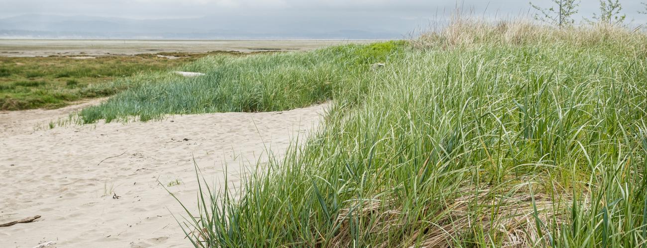
Leadbetter Point State Park preserves an otherworldly place of sand dunes, stunted forests, wildlife-filled wetlands and solitude at the northern tip of the Long Beach Peninsula on Washington’s southern coast.
Leadbetter Point showcases the dynamic and ever-changing nature of Washington’s Pacific Ocean coast. Massive volumes of sand and sediment are carried to the coast from deep in the interior of the state by the Chehalis River, Columbia River, and other rivers and streams. Once these sediments have emptied into the Pacific Ocean they are moved by waves and coastal currents.
Seasonal variations in the movement of sediments have shaped and re-shaped Leadbetter Point over time. In winter months, sediments generally migrate parallel to the coastline. In summer months the sediments are pushed toward the shoreline. Once the sand has been added to the beach, winds blow the sand grains farther. Predominant winds from the southwest and southeast mold linear dunes parallel to the coastline. Once plants have stabilized the deep and well-drained fine sand of the dunes, the linear depressions between dunes collect deep and poorly-drained loamy sand that frequently floods in the wet winter months.
Modifications to the natural ebb and flow of sand on the coast have come from dams that trap sediment on the Columbia River, dredging of navigation channels at the mouth of the Columbia River and the entrance to Grays Harbor, and the construction of jetties. Since it was first surveyed in 1859, the northern tip of Leadbetter Point has extended by nearly three miles, due to the accretion of sediment.
Leadbetter Point exists at the nexus of currents, tidal flows, and the mixing of salt and fresh water at the edge of the Willapa Bay estuary.
Indigenous Land
Leadbetter Point State Park lies within the traditional territory of Coast Salish Indigenous people whose present-day descendants include members of the Shoalwater Bay Indian Tribe and the Confederated Tribes of the Chehalis Reservation. For thousands of years the rich estuary of Willapa Bay has provided habitat for a diverse community of life that forms the basis of their cultures.
The abundance of fish and shellfish, especially oysters, in the bay’s waters was a mainstay for Indigenous people. Many had long-established winter villages on the bay’s shoreline, but traveled to other areas, including the Columbia River and Grays Harbor, in other seasons to take advantage of fish runs and to hunt and gather foods in inland forests and prairies.
James G. Swan, who traveled widely throughout Washington Territory in his various occupations as oysterman, customs inspector and secretary to Territorial Governor Isaac I. Stevens, visited Leadbetter Point on July 4, 1854, and recorded that he found “any quantity of berries—strawberries, blackberries, black currants and huckleberries. These berries the Indian women picked when the tide was up, but at low water they collected clams for drying, while the men shot seal, or caught sturgeon.”
Local tribes refused to accept the conditions proposed by Governor Isaac Stevens at the Chehalis River Treaty Council in February 1855. Subsequently, title to the land was relinquished to the US federal government and the Chehalis Reservation was established by executive order of Secretary of the Interior J. P. Usher on July 8, 1864. On September 22, 1866, President Andrew Johnson established the Shoalwater Bay Reservation by executive order.
What’s in a Name
In 1852, Lieutenant James Alden, Jr. named Leadbetter Point for an associate in the US Coast Survey, who had assisted in the detailed charting of the Northwest Coast. Danville Leadbetter later served with the US Army Corps of Engineers in Alabama, eventually purchasing a cotton plantation there. At the start of the US Civil War, Leadbetter joined the Confederate Army, becoming a brigadier general. During the war, Leadbetter purportedly oversaw executions of Union volunteers who carried out sabotage on southern railroad lines and bridges. Some accounts of the courts-martial of the captured raiders indicate that Leadbetter ordered that their corpses would hang for four days after their death.
After the war, Leadbetter fled to Mexico as part of a group of Confederate officers seeking to avoid prosecution for insurrection and war crimes by leaving the US. Leadbetter died the following year in Canada.
Oysters, Cattle and US Land Disposal Laws
Government surveys of Leadbetter Point were completed in 1859 and the land in today’s park passed into private ownership with Cash Entry Patents, a form of land sales from the public domain, issued between 1865 and 1884.
The land at the start of today’s Martha Jordan Birding Trail was bought by Judge Miles Standish Griswold. Griswold had traveled to California in 1852 in the gold rush but relocated to Oysterville by 1859. He served in the Washington Territorial Legislature 1861-1862 and was appointed as a probate judge for Pacific County.
Land around the southern Dune Forest Trailhead was purchased by Osborn and Gabriel Goulter to provide grazing land for their cattle ranching operation. Osborn Goulter built a road to access the property, mostly treeless grassland at the time. Originally called Goulter Road, it is today’s Stackpole Road. Judge Griswold officiated at the marriage ceremony for Osborn and Lydia Goulter in 1872.
Land traversed by today’s Weather Beach Trail was purchased by John, Thomas and Caesar Crellin. The Crellins were among the founders of the town of Oysterville in 1854. Export of oysters from Willapa Bay to California became a lucrative business, and the Crellins competed with oyster growers from Morgan & Co. in Bruceport across the bay, until their sister Sophia married owner John Morgan.
Making a Park
In 1952, the Washington State Parks and Recreation Commission (WSPRC) endorsed a plan to apply to the federal Bureau of Land Management for acquisition of nearly 800 acres of federal land at Leadbetter Point, accreted by sand and sediment in coastal currents since the government survey of 1859, for state park purposes.
Meanwhile, the WSPRC began a discussion with Washington Commissioner of Public Lands Bert C. Cole about acquisition of additional lands south of the federal land at the tip of the point.
In July 1958, most of the land now making up Leadbetter Point State Park was acquired by the Washington Department of Natural Resources in a multi-party land transaction with landowners including a grandson of Osborn Goulter and the West Tacoma Newsprint Company, which owned timber-cutting rights on the property.
Commissioner of Public Lands Bert C. Cole ordered the withdrawal of the lands for park purposes in 1959, but the order was rescinded in 1963, when the WSPRC indicated that “they wish the lands to be held open for withdrawal at a later date,” awaiting a decision on the federal lands at the tip of the point. The federal lands were ultimately transferred to the Willapa National Wildlife Refuge, not the WSPRC.
The land was finally withdrawn and leased to the WSPRC on April 16, 1964. In 1971 the Washington State Legislature decided that continued lease of trust lands for park purposes was not in the best interest of the state and directed the Department of Natural Resources (DNR) and the WSPRC to negotiate a sale of the leased lands. The two agencies entered into a contract for the purchase of 15,083 acres in 24 parks, including 792 acres in Leadbetter Point State Park, at a total purchase price of $11.4 million. The contract for the purchase of Leadbetter Point State Park was fulfilled on October 7, 1992, ensuring the permanent protection of the land.
Additional land purchases have increased the size of Leadbetter Point State Park, including partnerships with the Trumpeter Swan Society and Columbia Land Trust that resulted in the acquisition of nearly 270 acres south of the existing park in 1990 and 2002 that include wetland habitat critical for trumpeter swans.
In 1989, the Washington State Legislature authorized the Trust Land Transfer Program. The legislature funds the transfer of state trust lands (land granted to the State of Washington at statehood for the financial support of public schools and other institutions) with special ecological or social values and low income potential out of state trust ownership to a public agency that can manage the property for those values. Money from the transfer provides revenue for the trust beneficiaries and is used to buy productive replacement properties that will generate future trust income.
237 acres were added to Leadbetter Point State Park through the Trust Land Transfer program in 1994, further protecting habitat areas on the southern edge of the park.
Restoring the Dunes
Before the 1900s, the coastal sand dunes at Leadbetter Point consisted of small hummocks with loose sand and native beach grass. The dunes provided habitat for the western snowy plover and streaked horned lark, birds which nested there. The introduction of two non-native grasses in the first half of the twentieth century significantly changed dune structure by encouraging taller, narrower dunes closest to the ocean, and made the landscape less resistant to erosion. The changes severely impacted populations of plovers and larks, by exposing their nesting sites to predators. The non-native introductions also crowded out a native plant called pink sand verbena (Abronia umbellata).
Ongoing restoration projects at the park are working to remove invasive beach grasses, so that the dunes can function as they have in the past, ensuring a future for the species that had become endangered by the loss of their necessary habitat.
Sharing the histories of Washington’s state parks is an ongoing project. Learn more here.

