Beacon Rock State Park History
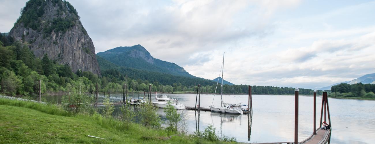
Beacon Rock State Park centers on the prominent rock monolith that rises more than 840 feet above the Columbia River, but the park’s landscapes and stories extend well beyond the rock.
Boring Volcanics
Beacon Rock is the core of an extinct volcanic cinder cone that erupted about 57,000 years ago. It is part of a volcanic feature geologists call the Boring Volcanic Field (named for the town of Boring, OR), as is the explosive caldera featured in nearby Battle Ground Lake State Park.
The slow-moving subduction of the oceanic crust of the Juan de Fuca tectonic plate underneath the North American continent in the Pacific Northwest produces molten magma that rises toward the surface. Sometimes, the magma reaches the surface and produces a volcanic explosion like the eruption of Mount St Helens in 1980.
The Boring Volcanic Field has a more mysterious story. Geologists continue to investigate the more than 80 lava flows, cinder cones and other features of the Boring Volcanic Field to better understand why these unique features formed here. The eruptions that are classified as part of the Boring Volcanic Field began about 2.6 million years ago, south of today’s Portland, OR. They are distinct from the volcanoes and uplift that continue to form the Cascade Range.
For some reason, melted ocean-floor basalt from the surface of the subducting Juan de Fuca Plate (about 30 miles below the surface of the Earth here, plunging to nearly twice as deep beneath the Cascade volcanoes) has been able to find passageways through the overlying rocks in the Portland-Vancouver area. This may be because the Juan de Fuca Plate is getting “stuck” by a very rigid part of the crust in the northern Oregon Coast Range and this has caused fracturing of the crust to the east. It may also be due to a localized tear in the Juan de Fuca Plate underneath the Boring Volcanic Field that allows heat from deeper in the Earth to rise and melt the overlying rocks, producing volcanic eruptions.
Ice Age Floods
During the last Ice Age, a lobe of ice at least a half-mile high blocked the Clark Fork River in Idaho, creating an enormous lake called Glacial Lake Missoula. Around 15,000 years ago, the ice dam failed—over and over—sending millions of tons of water rampaging across the land.
Thundering torrents of water, mud and ice raced through the Columbia River Gorge at speeds up to 60 miles-per-hour. The force of the floods stripped away tons of soil and rock, including everything but the hard core of the Beacon Rock cinder cone.
Indigenous Lands
Beacon Rock State Park lies within the traditional territories of Sahaptian and Coast Salish Indigenous people whose present-day descendants include members of the Confederated Tribes and Bands of the Yakama Nation, Confederated Tribes of Warm Springs Reservation, and other Chinook-speaking people. For thousands of years this area has provided habitat for a diverse community of life that forms the basis of their cultures.
Traditionally, the Indigenous people of the region left winter residences along the Columbia River and its tributaries in the spring to travel to various areas to collect, hunt, fish and trade on seasonal rounds. The rivers have long served as the primary transportation corridors in the region as well as the source of salmon, a mainstay of Indigenous food and culture. The series of cascades and rapids on the Columbia River upstream from today’s Beacon Rock State Park (now drowned by the reservoirs behind Bonneville and The Dalles Dams) were an economic and cultural hub of Indigenous life in the region.
Lewis and Clark
The Corps of Discovery, led by Meriwether Lewis and William Clark, passed by Beacon Rock on November 2, 1805. They had just completed a difficult passage of the Cascades of the Columbia three miles upriver. William Clark noted in his journal “a remarkable high rock on Stard. Side about 800 feet high & 400 yds round, the Beaten [Beacon] Rock.” The explorers’ journals also noted the presence of a large village about one mile downstream from Beacon Rock. Clark noted the landmark again on April 9, 1806, as they returned up the Columbia, its presence reminding them of the arduous passage through the Cascades of the Columbia ahead.
Treaty, Relinquishment and Land Distribution
Some local tribes ceded ownership of the area to the US federal government under duress in the Yakima Treaty of Camp Stevens in 1855, keeping rights to harvest natural resources in their usual and accustomed places including the Cascades of the Columbia River.
Government surveys were completed in 1865 and the land in today’s Beacon Rock State Park passed into private ownership under terms of various federal land disposal laws. Frontage on the Columbia River, including the Indigenous village below Beacon Rock, was claimed in 1865 under terms of the Donation Land Claim Act, which codified land claims for the earliest American migrants into the area.
Beacon Rock itself was purchased from the public domain as a Cash Entry patent by Philip Ritz, the namesake of Ritzville in eastern Washington, in 1870. Ritz later built 10 miles of the Northern Pacific Railway road-bed in the vicinity of his town and developed an association with railroad financier Jay Cooke. Ritz deeded ownership of Beacon Rock to Cooke, but after Cooke’s bankruptcy in the Panic of 1873, the land was sold to a neighboring landowner at a tax auction.
Today’s park campground and upper and lower picnic areas occupy land homesteaded by Thomas Danson in 1905.
The vast majority of the land that makes up today’s park was sold as Cash Entry patents in the 1890s to investors seeking to profit from the harvest of timber in the Hardy Creek and Hamilton Creek watersheds. Eventually, most owners failed to meet their tax obligations, and the tax delinquent land reverted to ownership by Skamania County.
Henry J. Biddle Rescues Beacon Rock
In 1904, the land parcel containing Beacon Rock was purchased by prominent Portlanders Charles and Sarah Ladd. In 1912 they sold a 2/3 interest in the property to the Columbia Contract Company to quarry stone from the rock to build the jetties at the mouth of the Columbia River. The company proposed to blast the rock with dynamite, then load the rubble onto barges for shipment to the river mouth. The quarry project was shelved when a railroad company successfully sued to condemn a portion of the property for a riverside rail line, effectively blocking the project.
In 1915, Beacon Rock and surrounding lands were purchased by Vancouver geologist Henry J. Biddle. He said he bought the parcel “simply and wholly that I might build a trail to its summit.” Biddle also purchased a Cash Entry patent of 160 acres of public domain lands including the summit of Hamilton Mountain. Biddle, along with Charles Johnson, constructed the trail to the summit of Beacon Rock.
The project, which Biddle financed at a personal cost of $10,000, was begun in October 1915 and completed in April 1918. Biddle said that “building a model trail in perhaps the most difficult location in which a trail had ever been built appealed to me most strongly.” The trail was built without surveying the route in advance, due to the inaccessible terrain. The finished trail was 4,500 feet long, 4 feet wide and had a maximum grade of 15%. There were 52 switchbacks, 22 bridges and over 100 concrete slabs to span gaps in the cliffs.
Creating a State Park
After Henry Biddle died in 1928, his children, Spencer Biddle and Rebecca Biddle Wood, approached the State Parks Committee about donating the land for a state park. The donation was refused by Governor Roland H. Hartley, who repeatedly vetoed any appropriations for the operation of the state parks during his second term in office from 1929-1932.
Subsequently, Samuel H. Boardman, the Superintendent of Oregon State Parks, sought to acquire the land as an Oregon state park inside Washington. A discussion with Rebecca’s husband Erskine Wood was made public in regional newspapers, resulting in lobbying for establishment of a Washington state park.
On April 14, 1935, the State Park Committee accepted the donation of 265 acres from the Biddles, including Beacon Rock, Hamilton Mountain and the site of today’s park campground and picnic areas.
Additional donations from private successors of the timberland cash entry patent holders in 1935 and a massive donation of 2,227 acres of tax delinquent lands from the Skamania County Commissioners in 1938 dramatically increased the size of the park, still one of the largest state parks in Washington.
A plaque commemorating the work of Henry Biddle was dedicated in a ceremony in September 1937 attended by 300 people.
The Civilian Conservation Corps
In the 1930’s as the Great Depression deepened, people throughout Washington and across the US struggled with poverty as job losses and business closures erased their economic security. Newly elected President Franklin D. Roosevelt moved fast to provide material relief for suffering families, and one of the earliest hallmark programs of the administration was the Civilian Conservation Corps (CCC). Intended to provide useful employment and training for single men aged 18 to 25, the CCC ultimately provided jobs for more than 2 million enrollees who performed work in national and state parks and forests at more than 500 camps.
CCC Company 2945 arrived at Beacon Rock State Park in August 1935 but was transferred to US Forest Service projects the following May. CCC Company 5709 arrived in the park with enrollees from Arkansas in October 1936. Three more CCC companies followed in succession, working on projects at the park until 1940.
Camp life was similar to other locations, with a recreation hall and educational opportunities provided, as well as trips into town on weekends for movies and religious services. Much of the work in the park involved restoration of areas burned in a wildfire in 1929. Other projects included road and trail building, including improvements to the Beacon Rock trail built by Henry Biddle. Crews also built a caretaker house, community kitchens, and campground and picnic areas.
Land acquisitions have continued to expand the park and the stories of its landscapes. The Doetsch farm property was purchased in 1987, including the site of the Indigenous village described in detail in the journals of the Lewis and Clark Expedition, and the Woodward family Donation Land Claim.
Sharing the histories of Washington’s state parks is an ongoing project. Learn more here.

